by doogyhatts
Littlecube Maps: Tropical Oasis Islands
IPFS

1 / 2
21 January 2023•TEZOS•IPFS
Littlecube Maps is a cartography art project that showcases procedurally generated islands of different sizes and biomes, surrounded by seawater. The motivation behind this project was to explore how small voxels can be used as a meaningful foundation layer for generating fantasy maps. Our inspirations came from Wolfram von Funck's work on Cube World and Scott Turner's work on Dragons Abound.
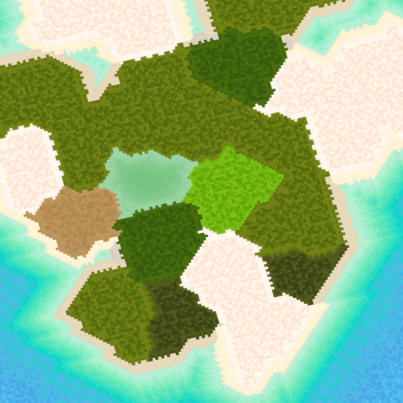
Tropical Oasis Islands consist of four large islands and several medium-sized islands situated in an equatorial climate.
The first large island has a balance of desert and shrubland regions. It also has a greenish algae-water lake, which is surrounded by shrubland regions, a grassland region, a marsh wetland region, and a dry-broadleaf forest region. There are two inlets on the northern side of this island.
The second large island also has an algae-water lake. However, it is surrounded by marsh wetland regions, a bog region, a sandy desert region, and a dry-broadleaf forest region. There are grassland and shrubland regions on this island. There is also an inlet on the northern side of this island.
The third large island has several dry-broadleaf forest regions grouped together at its center, separating two large sandy desert regions on each side. There are shrubland and coastland regions on this island as well.
The fourth large island has a lot of sandy desert regions, with several dry-broadleaf forest regions grouped together. There are shrubland and coastland regions scattered around this island. There are also two smaller inland lakes.
There is a medium-sized island that mainly has coastland regions. It has a greenish algae-water lake, surrounded by many bog wetland regions and a marsh wetland region.
The seawater around these tropical island reefs is set to be turquoise. Shallow seawater will approach and recede from the beaches, while the seawater around the reefs flows along its contours around the island. The deeper seawater regions flow in a south-west direction with a web of wave crests.
Controls:
To move the camera around the scene, hold down the left mouse button within the display panel and away from the center.
To rotate the camera view, press 'C'.
Automated Camera Movement:
When the camera has not been activated by the user for a while, it will engage in automated movement around the scene. So sit back, relax and enjoy the scene.
Other information:
This is a 1/1 artwork.
The application requires a GPU capable of WebGL2 and has been tested on Chrome,Brave & Edge desktop browsers.
It may take a few seconds for the application to prepare the scene data on a slow computer.
The overview of the technical solution is documented in our technical blog posts on fxtext.
Frameworks used: three.js, jsrand
Copyright(c) 2022 Edwin Zeng, @doogyhatts on Twitter
License under CC BY-NC-SA 4.0
Indie game developer for Littlecube Valley, a research-oriented game project using NFTs.
Research & development engineer (Computer Graphics).
Digital artist making living worlds and animations using voxel art.
1 EDITIONS
•0 RESERVES
minted
1 / 1
fixed price
5 TEZ